Terrain
To keep a safe distance from potential avalanches, you need to be able to recognise avalanche terrain.
19 articles
In winter, when there is snow and it is steep enough, an avalanche can release. Avalanches are set off by the interplay between terrain, snowpack and weather — and by ourselves when we move through terrain where those factors have set the stage. The subject is a large one, but for the ordinary hill walker it is enough to learn the few things that actually decide whether you build a safe relationship with the winter mountains or not.
Every time you are out in potential avalanche terrain, there are four things you take in at once:
The model is often called the avalanche triangle (Brattlien 2011) and places the person at the centre of the three environmental factors. It is rarely just one of the factors that is the problem — it is how they interact.
More on terrain → · The snowpack → · The weather → · The person →
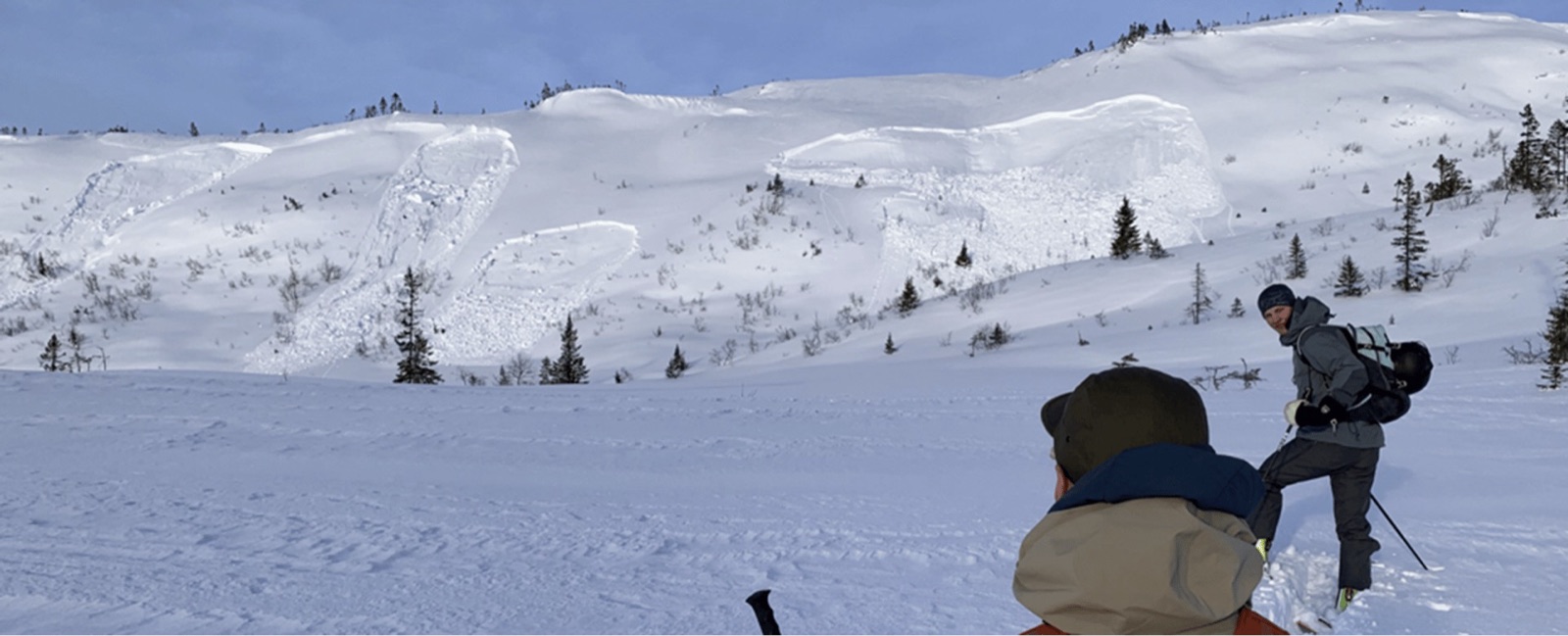
The slab avalanche is the most dangerous. A coherent slab of compressed snow releases along a weak layer and slides out. Dry slab avalanches can reach 130 km/h in 6 seconds. 99% of avalanche accidents happen in slab avalanches — and many are triggered by the skier themselves.
Recognised by:
The loose-snow avalanche starts at a single point and spreads out in a pear shape. They are usually smaller, but can still be dangerous in terrain traps or after heavy snowfall (30 cm or more in 24 hours).
Avalanche types and variants on Varsom →
A slab avalanche consists of three layers:
One alarm signal that is easy to recognise: snow that “cracks” around the ski as you walk. It means the snow is bound and can behave like a slab. If you hear or feel sudden whumpfing sounds in the snow, it is a sign that a weak layer has just collapsed beneath you — go back the way you came.
More on whumpfing sounds in the snow →
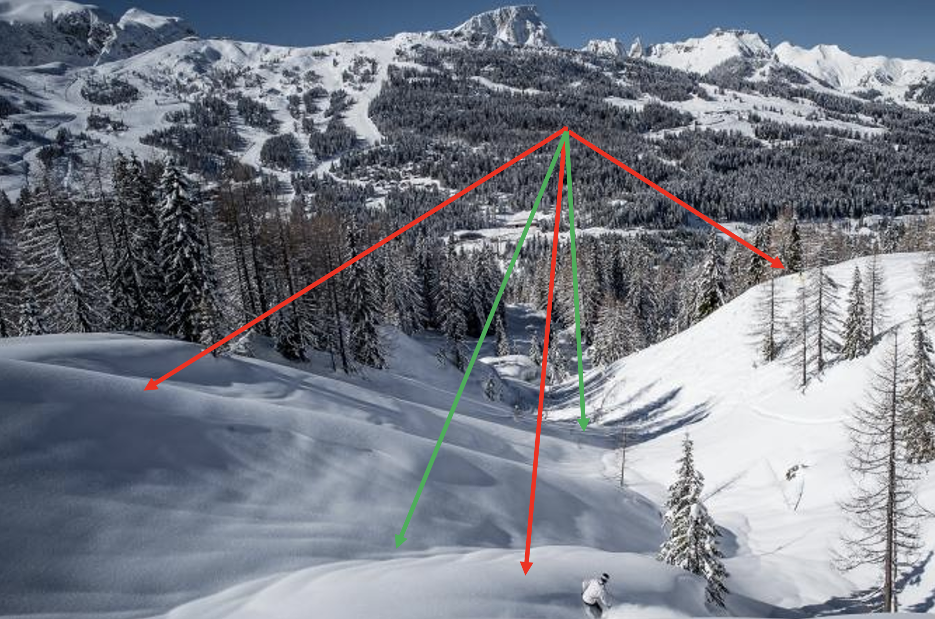
Good trip planning always starts with the terrain — not with the weather or the snow, but with the map. If the route you have chosen avoids 30-degree slopes and their runout zones, you are already most of the way there.
The most common systematic assessment is the 3×3 filter model (Nes 2013): you assess terrain, snow/weather and the group at three levels — trip planning at home, an area assessment when you park, and an individual slope assessment along the way. Each level is a check on the previous one, and any of them can stop the trip.
Reading an avalanche forecast → · Trip planning and safety →
Studies consistently show that a good understanding of terrain is the most important thing for safe travel in the winter mountains. Hallandvik, Andresen and Aadland (2017) showed that inexperienced travellers systematically assess terrain as less complex than it actually is. A New Zealand study (Salmon et al. 2014) found that 50% of accidents happen in terrain that actually was avalanche-prone — people often knew it, but did not act accordingly.
That means the single most important skill to practise is reading terrain on the map and from a distance: steepness, slope aspect, terrain traps, runout zones. More than reading snow, more than interpreting the weather, more than using the avalanche transceiver.
Avalanche equipment makes sense after you have learned to avoid avalanches — not as a substitute. In steep terrain where avalanches are possible, an avalanche transceiver, probe and shovel are mandatory:
The equipment reduces avalanche fatality considerably — a competent group can dig out a buried person in under 15 minutes, while an inexperienced group struggles to keep under 30. The difference is often life or death. But: equipment without competence is almost worthless. An avalanche course is just as mandatory as avalanche equipment.
Norges Skiforbund — ski touring courses · Norsk Fjellsportforum — course overview
Varsom categorises avalanche danger by five avalanche problems that call for different assessment criteria:
Each problem has its own assessment criteria. The details are covered in the avalanche problems category and directly on Varsom.
To become safe in the winter mountains:
Text: Linda Hallandvik, Snuitide (2022), revised 2026. Cover photo and figures: Varsom.no (NVE).
Key resources: Varsom.no (avalanche forecast and the avalanche school) · NVE bratthetskart · NGI · Norsk Fjellsportforum
Sources: Brattlien, K. (2011). Den lille snøskredboka. Fri Flyt. · Nes, C.L. (2013). Skikompis: snøskred og trygg ferdsel. Selja. · Hallandvik, Andresen & Aadland (2017). Decision-making in avalanche terrain, Journal of Outdoor Recreation and Tourism. · Tremper, B. (2008). Staying alive in avalanche terrain. Mountaineers Books.
To keep a safe distance from potential avalanches, you need to be able to recognise avalanche terrain.
Well over 60% of avalanche accidents are caused by human failure in one way or another (Tremper, 2008). We will look at why we make mistakes, and how we can reduce these mistakes.

The snowpack is the most complicated factor to make an assessment of in relation to avalanches (Fredston & Fesler, 2011).
Precipitation, temperature and wind are important factors when we assess the weather and the avalanche danger. The weather can increase or reduce the avalanche danger in the winter mountains.
5 entries
8 entries
2 entries