Avalanches
Avalanche exercises
1. Which two main types of avalanche do we have?
- Which two main types of avalanche do we have?
- Why do avalanches happen?
- Where do avalanches happen?
- When do avalanches happen?
- Which danger signs indicate high avalanche danger?
Trip planning for avalanches
- Take a look at the map of an area you know well. Can you spot various places that it might be wise to avoid (for example, the release area and the runout area)?
- If you click on this link, you will be able to navigate to your area. Choose a trip you usually do, or are planning a trip to, and look at different route choices around this area. Discuss with others what might be a sensible route choice in your chosen area.
- Look at RegObs for your area. What does the avalanche forecast tell you?
- Which danger signs warn of increased avalanche danger, and why?
Practical exercises
- Use the 3x3 filter method when you are out on a trip. What do you look for, and how do you assess the three factors: weather and conditions, terrain, people?
- Practise using different methods to measure steepness. Try both with a pole and with a clinometer if you have one. Which works best for you? Why?
- Assess your route choice against what you planned in advance. Is the route you drew up beforehand the best one, or are there better alternatives in terms of safe travel? Does the terrain look different from what you expected? What might be the reasons for this?
- See whether you can find different terrain traps when you are out on a trip. Can you see why these terrain features are called ‘traps’?
- How has the weather affected the snow where you are out on your trip? How does this affect the avalanche danger?
Calculate safe travel
When there is a danger of avalanches, you can use maps and mathematics to calculate the safest route in the terrain.
The rule of three
If you are 500 metres below the summit of a mountain where there is a danger of avalanches, you must be three times as far away, i.e. 1500 metres from the summit, to be completely safe.

Illustration: nyhetsgrafikk.no CC-BY-NC-SA-4.0
Exercise
A skier is standing by the red arrow on the map and is out on a trip along the dashed route that continues around Halletjørne. The ice on the lake is safe, and the skier wants to go straight across the lake to save time.
It may look as though there could be a danger of avalanches at the mountainside Nattane.
Use the information above about the rule of three to calculate the route the skier should follow in order to avoid being in the danger zone in the event of an avalanche.
On the map, the contour lines are 50 metres apart.
a) Draw an auxiliary figure of the mountain with measurements.
b) Calculate the runout angle.
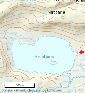
c) How far from the mountain should the skier go? Use the information above.
d) Calculate the runout angle if you follow the rule of three.
e) Will the skier travel safely across the lake with regard to avalanches?
Suggested solution:
Snøskred - Matematikk 1P-Y - BA - NDLA
Text: Elisabet Romedal, NDLA (CC BY-SA)
Text
- Exercises ‘Snøskred’: Gina Wigestrand, Snuitide (2022)