Navigation
Grid reference — for telling people where you are
How to read a six-figure grid reference from the UTM grid, and how to give your position precisely whether you are calling 113 or sharing a trip tip with a friend.
When you hold the map so that you can read what is written on it, the top of the map points north. The map has a grid of lines. The lines run from the top to the bottom of the map (north–south), and from the left to the right side (west–east). These are auxiliary lines in a coordinate system. The coordinate system makes it possible to specify the position of any point on earth using letters and/or numbers.
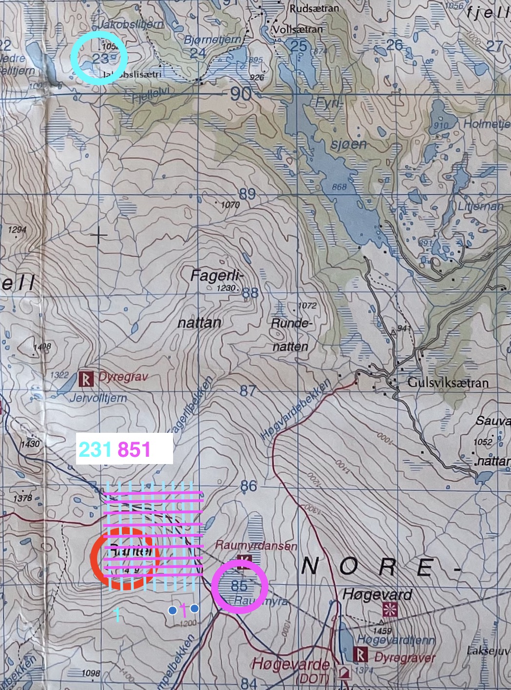
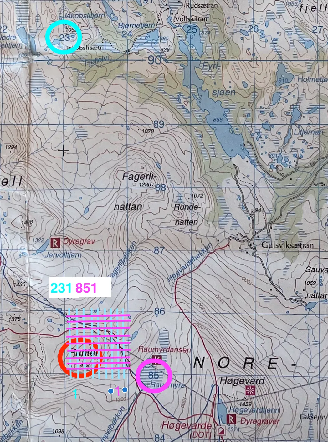
A grid reference is usually given with six figures: three figures from the east–west coordinates (the x-axis) and three figures from the north–south coordinates (the y-axis). First you find the kilometre grid line for east–west — the numbers are given with two figures in blue (marked with a blue ring in the picture). Then you divide the square into ten parts (blue lines in the picture) and estimate how many parts to the right of the kilometre line you are. Then you do the same with the north–south coordinates (marked in purple). Remember to state which map you are using, for example ‘map of Lysefjorden — 1:50 000’ or ‘map of Nordmarka 1:25 000’, since different maps can have the same grid reference.
Example: the grid reference for the mountain ‘Ranten’
The grid reference for the mountain ‘Ranten’ is 231851.
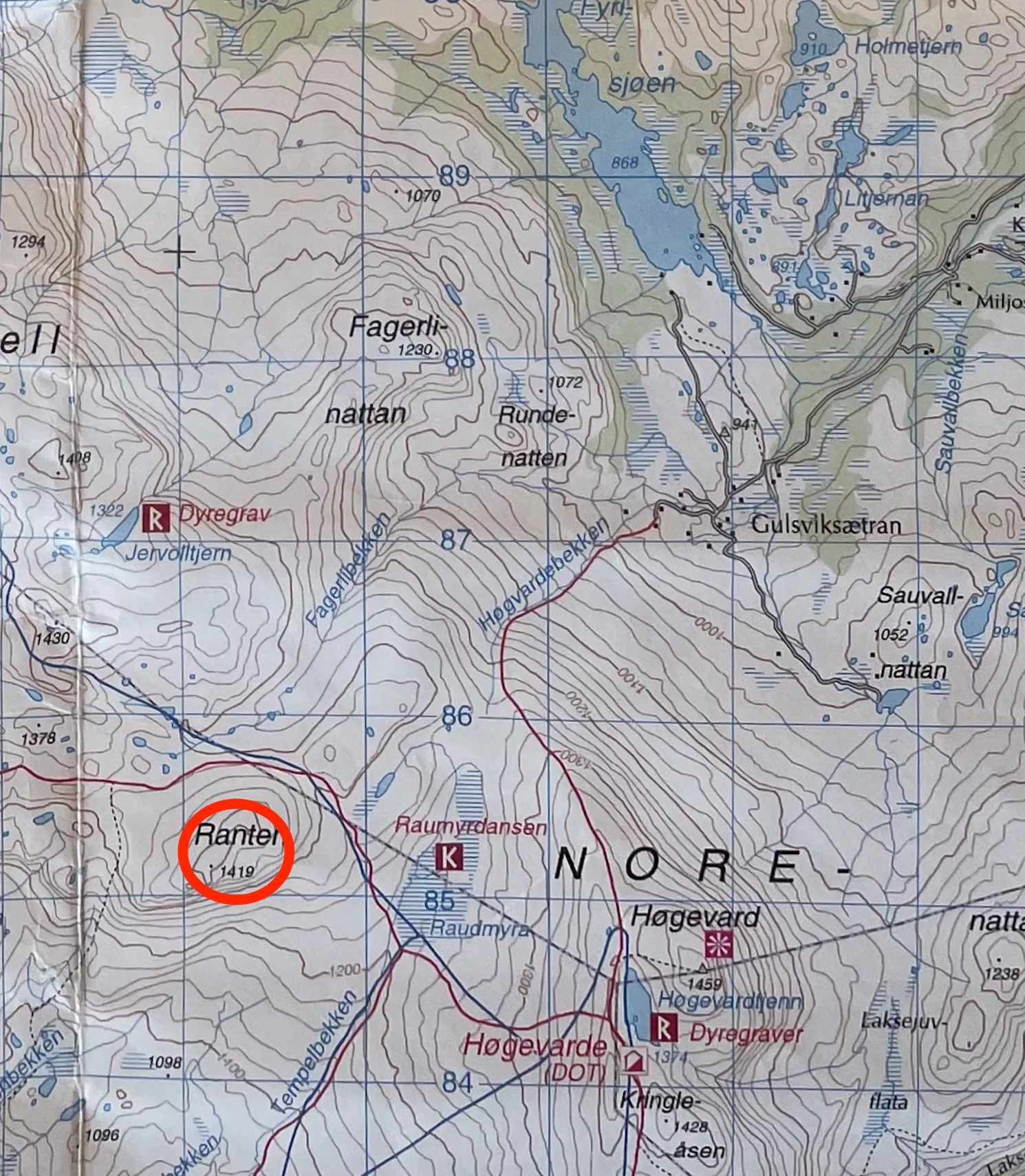
The summit is marked as a dot at 1419 metres above sea level. Illustration: Gina Wigestrand, Snuitide.
In the door, up the stairs. Or x,y for those familiar with graphs and coordinate systems. Illustration: Gina Wigestrand, Snuitide.
More about coordinates and grid references
The earth is divided into lines of longitude and latitude. This gives you coordinates divided into degrees, minutes and seconds. This form of position reference is commonly used on boats or at the poles.
On land maps a system is used that divides the earth into zone belts. This is called UTM/UPS. The zones are divided further into letter codes that make up 100-kilometre squares. On newer maps the letter codes have been replaced with number codes (Wangberg and Heimdal, 2021).
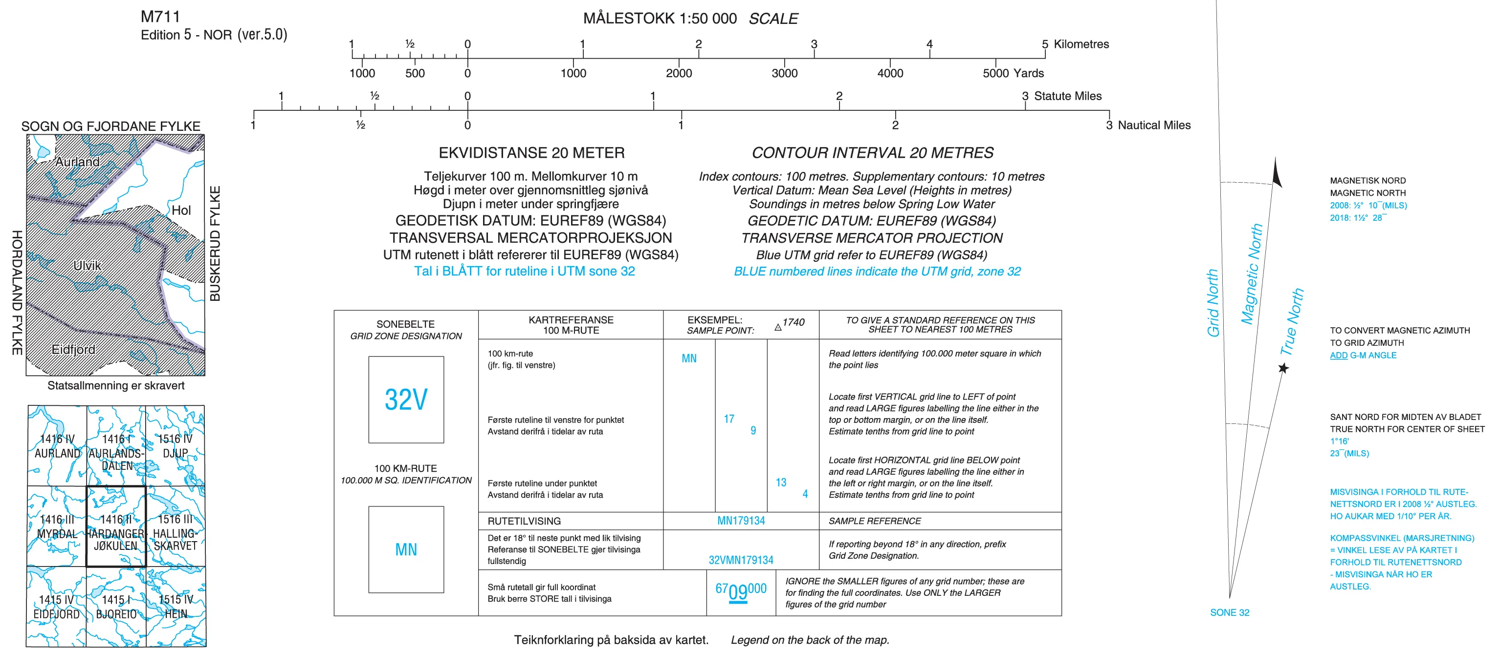
On the Hardangerjøkulen map (on the right-hand side) the zone belt is 32V, while the letter code for the 100-kilometre square is MN. On newer maps the 100-kilometre square is shown as small blue numbers in the margin — see also Contour interval and scale for how to read the blue numbers. The GPS gives full coordinates with 14 numbers, plus the zone belt. On the GPS the 100-kilometre square is given with two numbers for east/west and two for north/south (the first two numbers).
On a GPS the coordinates can look like this:
32 V 03 92806 67 93746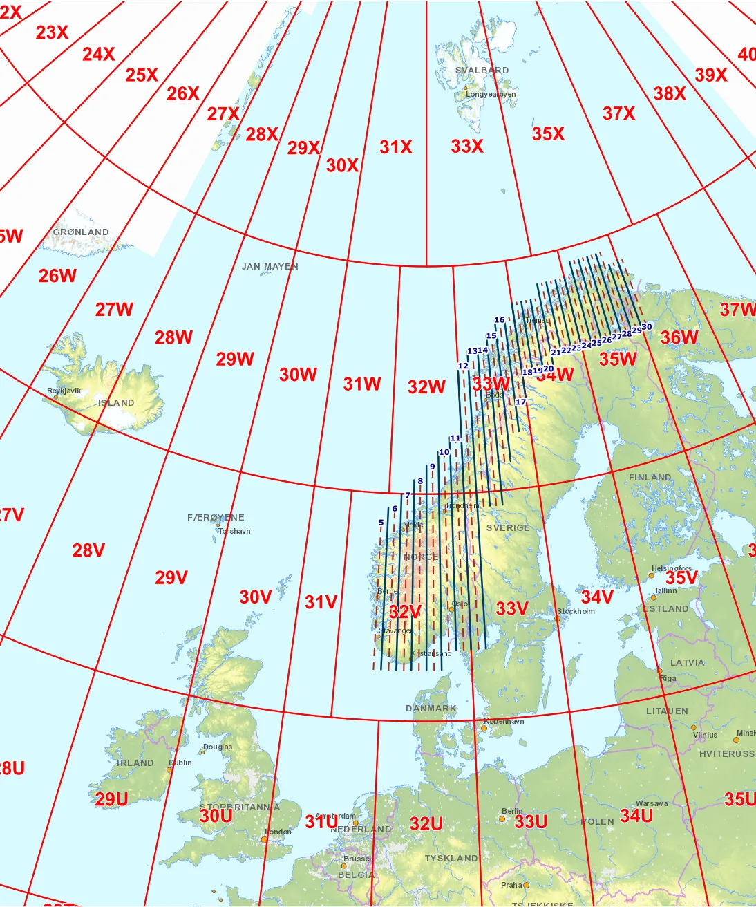
Overview of the zone belts in Norway. Southern Norway up to Trondheim is covered by the zone belt 32V. Illustration: Esri, USGS, HERE, FAO, NOAA, Kartverket.
Statens kartverk, M711-serien, Hardangerjøkulen 1:50 000 (Copyright Statens kartverk). NB! This map series is discontinued and can no longer be bought in shops.
A grid reference given on land maps is usually given with six figures. For this you have to look at the blue numbers in the margin of the map. You skip the zone belt (32 V) and the small blue numbers on the map (which indicate the 100-kilometre square). The next two numbers are the blue numbers shown in the margin of the map.
The last figure shows how far into the 1-kilometre square you are. If we use the coordinates from the GPS above, the grid reference becomes 928937. It is important to say which map you are giving the reference from, since several maps can have identical grid references (Wangberg and Heimdal, 2021).
In practice: when do you need a grid reference?
- Emergency number 113: in the event of injury in the mountains, a grid reference + map name is the fastest way for the police and the air ambulance to reach you. Say the map name first, then the six figures.
- Agreeing a meeting point: ‘We meet at 928937 on the Hardangerjøkulen map’ is precise enough for two groups to find each other.
- Sharing a trip tip: ‘A spot suitable for a bivouac at 231851 on the Jotunheimen map’ takes the reader straight there.
More about navigation
Contour interval and scale · Compass course · GPS · Magnetic variation · Cross-bearing · Navigation at sea · Printing maps from the internet
Text: Gina Wigestrand, Snuitide (2021), revised 2026.
Sources: Kolbjørnsgard, S. (2022). Kartreferanse [Video clip]. https://vimeo.com/736815328 · Unger, L.C. (2010). Orientering. I Blystad, J.T. (red.), Turlederboka (s. 67–83). Oslo: Den Norske Turistforening. · Wangberg, S.L. og Heimdal, L. (2021). Hvordan bruke kart og kompass. Utemagasinet. https://www.utemagasinet.no/uteskole/hvordan-bruke-kart-og-kompass