Navigation
Navigation at sea
How to read a nautical chart, fix your position using latitude and longitude, and take a course with a parallel rule. With a paddling-speed table, free school charts and practical resources.
At sea you use a different coordinate system than on a land map. Position is given in latitude and longitude, and you take a course on a nautical chart with a parallel rule instead of a compass against a grid. Here is how to do it.
Longitude and latitude
The Earth is divided into lines of longitude and latitude. This gives you coordinates divided into degrees, minutes and seconds. This way of giving a position is commonly used in a boat or at the poles.
Lines of longitude (meridians) run in circles from north to south. They meet at the North Pole and the South Pole. Lines of latitude (also called parallels of latitude or parallel circles) run across, parallel to the Equator.
The zero point for latitude is the Equator, while the zero point for longitude is the ‘Greenwich meridian’, which runs through Greenwich in Britain.
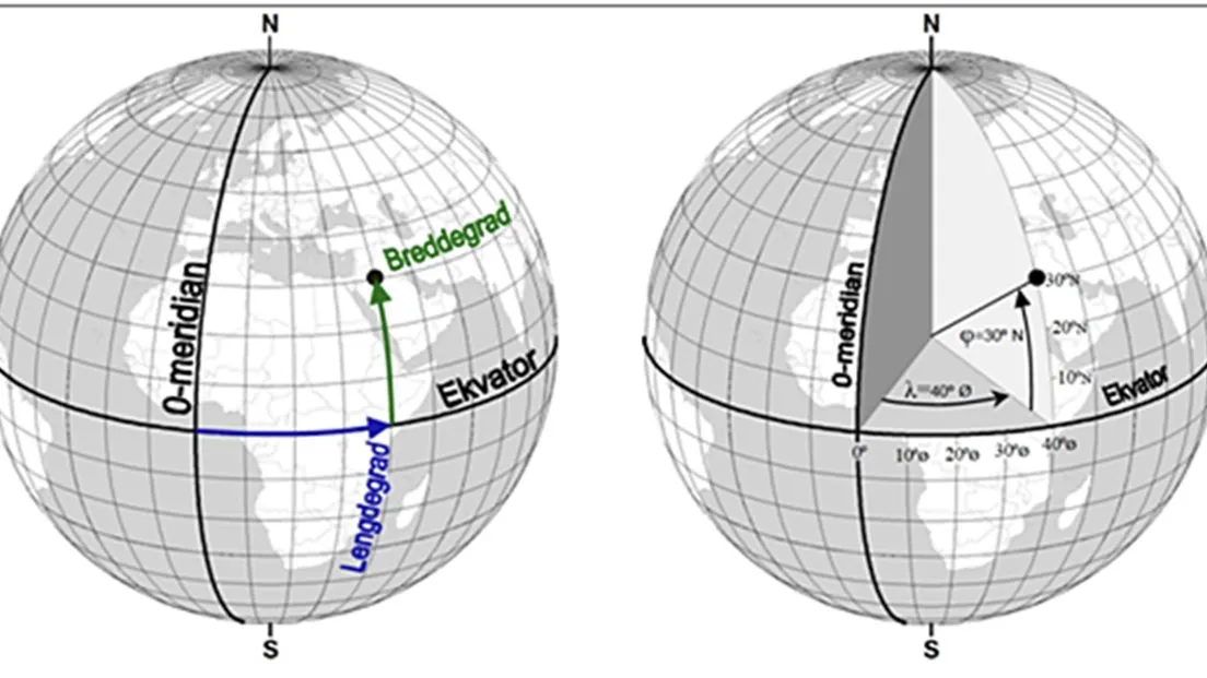
Figure: Kartverket (n.d.).
Minutes and seconds
Each degree of longitude and latitude is divided into minutes and seconds to give a more precise position. Each degree is divided into 60 minutes, and the minutes are divided further into seconds.
The distance between the parallels of latitude is constant, regardless of position. A minute of latitude always corresponds to 1 nautical mile — which is 1852 metres. Lines of longitude vary, with greater distance the closer you are to the Equator.
Finding your position on the chart
Watch the film: Finding your position on a nautical chart.
Example of a position to find on the chart: N 59°06.5′ E 10°28.7′.
- Find the latitude and longitude on the chart:
- The latitudes are on the sides
- The longitudes are at the bottom and top
- Find the minutes:
- Minutes of latitude: Count upwards from 59 degrees to 6 minutes and 5 seconds. Mark it off on both sides of the chart.
- Minutes of longitude: Count across from 10 degrees, 28 minutes and 7 seconds towards the right. Mark it off on both sides.
- Use the parallel rule to draw a line between the dots:
- Draw one horizontal and one vertical line
- The crossing point is your position
Taking a course at sea
It is wise to take a course so that you know you are moving in the right direction. If you have a land map, you can take the course with a compass. If you have a nautical chart, the parallel rule is the thing to use.
Watch the film: Finding a course on a nautical chart.
How to take a course on a nautical chart:
- Find the position where you are.
- Find the position where you are going.
- Use the parallel rule to draw a line from where you are to where you are going.
- Move the parallel rule so that the course passes through the centre of the compass rose on the chart.
- Make sure you read off the degrees in the compass direction you are heading
- Read off the degrees on the outermost ring of the compass rose
- Draw a line on the compass rose to make it easier to read off.
- Enter the number of degrees on your compass or a GPS.
Free school charts
Kartverket offers free school charts. The school charts are extracts from ordinary nautical charts, made for use in teaching and for practising the use of nautical charts.
Time and distance at sea
In short:
- Know the scale of the chart.
- Use your thumb or a chart plotter to measure distance.
- Paddling speed depends on the number of people and on experience:
| Speed (kayak) | Minutes per km | Group | Experience |
|---|---|---|---|
| 4 km/h = 2 knots | 15 | Large — more than ten | Beginners |
| 5 km/h = 2.5 knots | 12 | Large — more than six | Less practised |
| 6 km/h = 3 knots | 10 | Small — up to six | A little practised |
More on nautical charts and navigation
Kartverket — Den gode opplevinga på sjøen · Båtvett — Symboler i sjøkart · Kartverket — Transformere koordinater
More on orienteering
Compass course · Grid reference · Magnetic variation · Cross-bearing · GPS · Contour interval and scale
Text: Snuitide (2022), revised 2026.
Sources: Kartverket (n.d.). Kva er eit kart?. · Båtvett — course videos. https://batvett.no/kurs/.