Gear
Compass
A baseplate compass with a rotating housing is the standard for trips in Norway. Magnetic variation, models, and why you should practise using it at home before you need it in fog.
The compass is the simplest, most reliable navigation tool we have — no batteries, no coverage, no updates. A good compass lasts 30+ years. A poor compass breaks after its first season or points the wrong way.
For using a compass — setting a bearing, fixing your position, mountain trips in fog — see orienteering. This article is about the equipment.
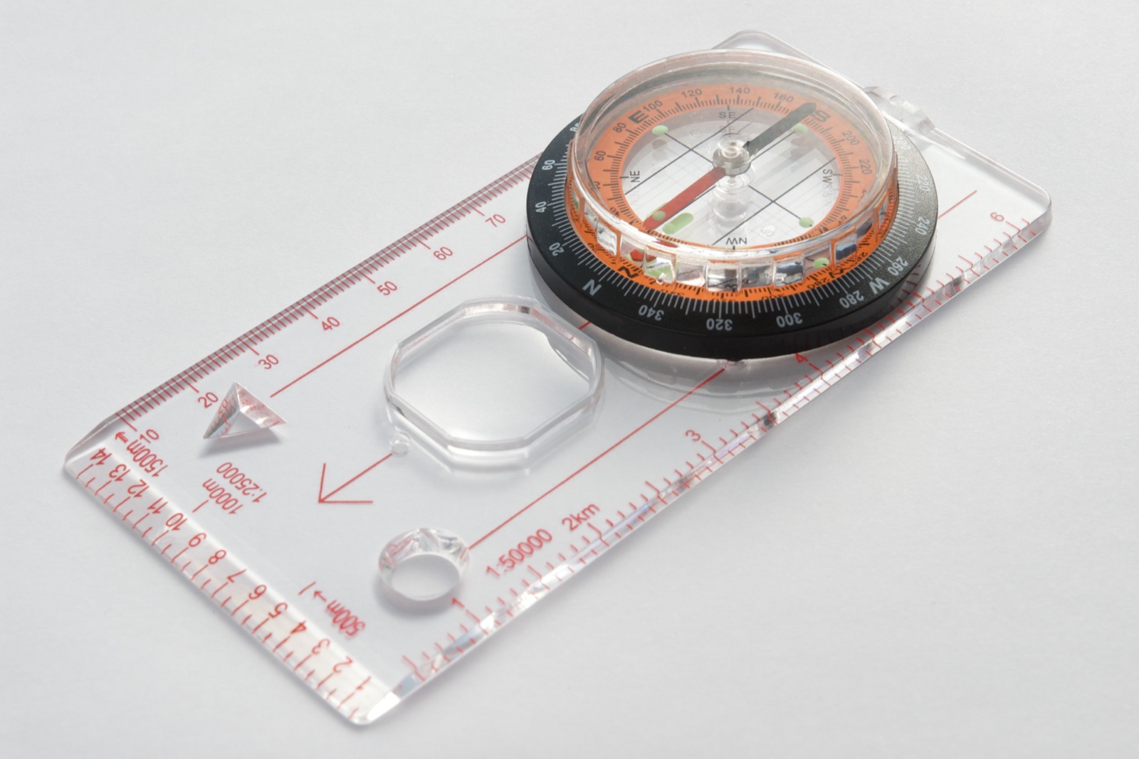
The baseplate compass — the standard model
A baseplate compass consists of a transparent baseplate, a rotating housing with a graduated ring (0–360°), and a magnetic needle. Classic examples: Silva Expedition 4 or Suunto MC-2. Price: 350–800 kr.
The most important parts:
- The baseplate — transparent, with the direction-of-travel arrow and lines for map work
- The housing — a graduated ring that you rotate to set a bearing
- The needle — floats in liquid (typically oil) so it settles steadily, the red end pointing to magnetic north
- The magnifying lens (on some models) — for map detail
- The lanyard — for hanging round your neck
For Norwegian trip use, the baseplate compass is without exception the right choice. Other forms (card compass, watch compass, phone compass) are not precise enough or reliable enough for real trip navigation.
Magnetic variation — compass vs map
Magnetic north (what the compass points to) and geographic north (what the map grid points to) are not the same point. The difference is the magnetic variation — in Norway it ranges from ~3° in southern Norway to ~10° in Finnmark, and changes over time (~0.1° per year).
For accurate map work you have to adjust for magnetic variation. Many modern baseplate compasses have a declination adjustment (a small screw that lets you set the local variation permanently), so you do not have to recalculate every time.
Check the local magnetic variation on Kartverket or on the map you are using — it is usually printed in the map margin.
Practical details
An elasticated lanyard sits round your neck and lets the compass hang outside your jacket when you are not using it.
A thermometer is built into some models — useful for checking whether you are above or below freezing.
A magnifying lens is useful on 1:50 000 maps where path symbols and terrain detail are small.
A light-sensitive or luminous housing lets you read the compass in low light (dusk, a snow cave).
A clinometer (for measuring slope angle) is built into some models — useful for assessing avalanche slope angle.
Do not use a compass near metal
Magnetic objects disturb the compass. Keep your distance from:
- A mobile phone (especially the camera, with a magnet in the lid)
- A car battery
- Jewellery and belts with metal
- Steel spades
- Carabiners and other metal climbing gear
Rocks can in rare cases (iron-bearing rock types, magnetite clay) disturb the compass over short distances. If the compass behaves unexpectedly, move 50 m and test again.
Models
Silva (Swedish) — the reference brand. The Expedition series (Expedition 4, Ranger, Nor) is for trips. The circle is high quality and the housing is precise.
Suunto (Finnish) — the MC-2 and A-30 are classics, good Finnish equipment.
Recta (Swiss) — the DT models are precise and durable. Often preferred by professional navigators.
For a Norwegian start: the Silva Expedition 4 (with declination adjustment) is the most common choice.
Maintenance
Check that the needle floats freely — if it sticks or drags, check whether there is a bubble in the liquid. Small bubbles are normal; large bubbles indicate the compass needs replacing.
Keep it dry — water in the mechanism can disturb the housing. Dry it after wet trips.
Do not boil it — heat above 60 °C can ruin the liquid or the plastic.
Do not carry it together with magnetic objects over a long period — it can demagnetise the needle.
Map → · Map case → · Orienteering — the category →
Text: Snuitide (2026), based on documentation from Silva, Suunto and Kartverket.