Navigation
Navigating by nature's signs
Although you should always carry a map and compass, sometimes you find yourself out in nature without either.
Although you should always carry a map and compass, sometimes you find yourself out in nature without either. Perhaps you only meant to go for a round in familiar surroundings, and you took a little detour. Perhaps the map case fell out of a pocket. Do not despair! There are several signs in nature you can use to orient yourself that can help you find your way.
The sun
The sun is a good guide, since it moves along the same path every day (leaving aside the polar night in the north). The sun rises in the east and sets in the west. In the middle of the day the sun is in the south. This is usually around twelve to one o’clock in the day.
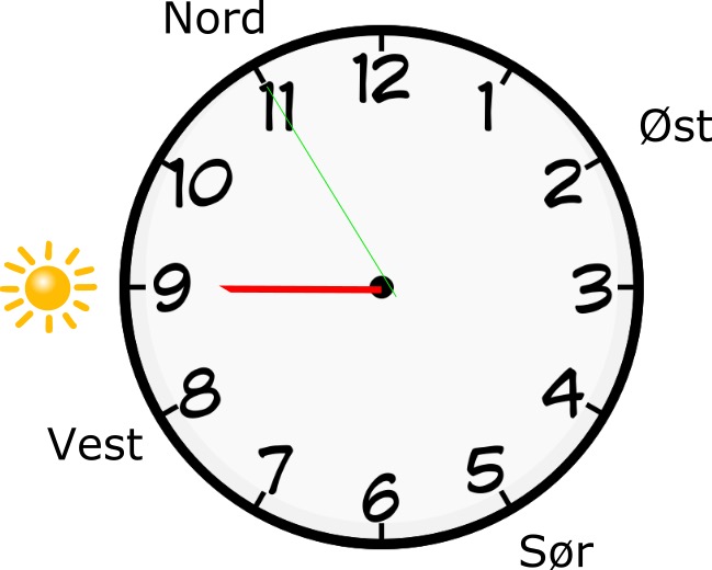
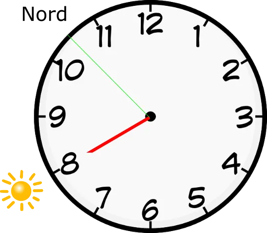
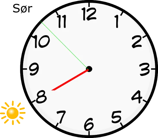
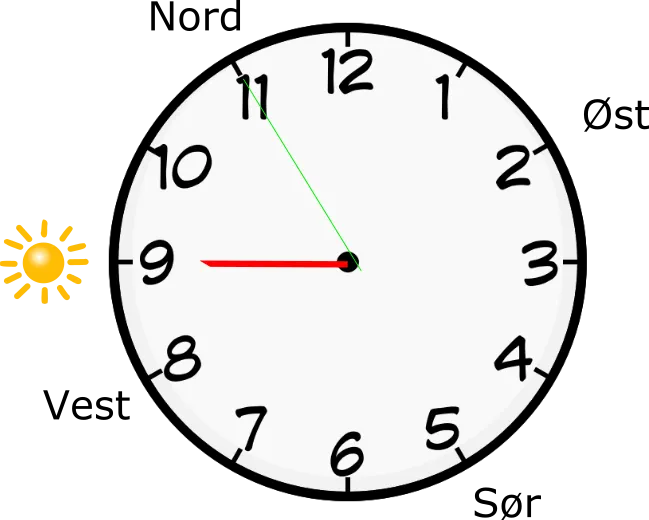
If you have a watch with hands on you, you can easily find the points of the compass. Hold the watch flat in front of you. Turn so that the hour hand points towards the sun.
Now you need to find the point midway between the hour hand and twelve on the dial. When the watch is set to summer time, you find the point between the hour hand and the one on the dial, instead of twelve, since the watch has been set forward an hour.
The point you find will point either towards the south or the north. This depends on the time of day.
You find the point on the side of the watch the hour hand is on.
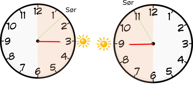
At three o’clock (winter time) the southerly direction falls between 1 and 2 on the dial. At 09.00 (summer time) the south will lie at 11 on the dial.
Between 18.00 in the evening and 06.00 in the morning the point points towards the north.
From 06.00 in the morning to 18.00 in the evening the point falls in the south.
The same point on the watch will therefore show opposite directions to each other depending on the time of day, as shown in the example below:
20.00 hours 08.00 hours
Once you have found south or north using the sun and watch, it is easy to find the other points of the compass:
Naturally south-facing signs
Warmth and light are important to many species, both plants and insects. They will therefore orient themselves towards where these are most available.
As a general rule this means that many things in nature are oriented towards the south.
Ant hills, for example, are often on the south side of trees.
Vegetation usually gets the most foliage facing south.
Snow usually melts first on south-facing slopes.
💡Remember that these are not entirely reliable methods, and can vary with topography and vegetation. It can nonetheless be wise to keep an eye on such things, to get a rough indication.
Up = overview
Are you struggling to place yourself on the map and unsure where you are in your surroundings? Then it can be wise to make your way uphill towards a height where you can get a bit of an overview. In very flat terrain even a moraine ridge can be enough to give you a bit of an overview of the terrain. But remember – if you have lost your way, there is a chance you are moving further away from people and help if you move much uphill. So assess the situation, and avoid putting yourself in a more difficult situation than you are already in.
Downhill = people
Norway is a relatively small country, and we have settled more or less every part of it. That means that wherever you are in the country, you are usually not very far from people. If you want to find your way to people, the simplest rule of thumb is to go downhill. If you make sure to go downhill, you will sooner or later come to habitation. This is because we Norwegians have established ourselves in every valley, along rivers and lakes.
If you are in hilly terrain where it is hard to see what is up and down, the best thing is to find running water. If you follow the direction the water flows, you will go downhill.
This is a simple rule that works almost everywhere in the country, except perhaps the very most remote places, such as the innermost reaches of Femundsmarka or in Børgefjell national park. But even here – if you follow the flow of the water, you will eventually come to people. It may just take a little longer.
Text and illustrations:
Bjørn Henrik Stavdal Johansen, Snuitide (2022)
Next steps
- Navigation — the hub
- Map and compass — exercises — basic map work
- GPS — technology as a backup
- Navigation in the winter mountains — winter-specific
Learn more
- Kartverket — map base and symbols
- Norgeskart — interactive map
- Norges Orienteringsforbund — sport and courses
- UT.no — route data