Geology & Rocks
16 articles
Norway has high mountains and deep valleys. Much of the landscape we see today was shaped during the ice ages — the fjords are old valleys flooded by the sea, and the deepest, the Sognefjord, is 1,308 metres deep. It is the ice that carved them out.
Geology is the frame around everything we do in nature. Where you find good tent sites, why some mountains are steep and others rounded, why water gathers in particular valleys, where the farming villages lie — all of it has a geological explanation that reaches millions of years back.
The geological history of the Earth in brief
The Earth came into being 4.6 billion years ago — a molten inner core with a hard outer crust that is constantly moving. We call it continental drift. Life arose roughly 3.5 billion years ago, and has come close to extinction four times.
For Norway, two events matter:
- The Caledonian mountain-building (orogeny) around 400 million years ago, when Norway and Greenland collided and formed mountains that resembled today’s Himalayas
- Uplift from about 66 million years ago that gave us the mountains in their modern height — and thereby the basis for the ice ages to shape the valleys
Between these events Norway was eroded down to sea level once — then built up again.
The ice ages — what shaped what we see
Over the past 2.8 million years the Earth has gone through more than 40 ice ages. The pattern is an ice age of around 100,000 years and an interglacial of around 10,000 years. We are living in an interglacial now (and it has been more stable, warmer and longer than most earlier ones — perhaps a long time until the next ice age).
The last ice age lasted from 120,000 years ago to 10,000 years ago — 110,000 years of continuous cold. During it, most of the Norwegian landscape, as we know it today, was shaped.
At its greatest, the inland ice stretched all the way to Poland, Germany and France. Norway lay beneath an ice cap that was up to 2,000 metres thick in places. When the ice disappeared, the land rose — the marine limit (the sea level after the last ice age) today lies up to 220 metres above the present sea level in the inner Oslofjord and Trøndelag. The Bothnian Bay (Bottenviken) is still rising measurably.
How the landscape came to be
U-shaped valleys and fjords form when glaciers settle into weaknesses or existing valleys and carve them deeper over tens of thousands of years. Water freezes in cracks (expanding by about 10 % and acting like dynamite), and the ice carries away coarse rock. The Sognefjord is 1,308 metres deep, and the Hardangerfjord 800+ metres — both are old valleys the ice deepened sharply.
“En skikkelig U-dal er alltid et forfriskende syn. Jeg har ofte litt vanskelig for å snakke med folk som liker V-daler.” — Erlend Loe, Jotunheimen — Bill. mrk. 2469
V-shaped valleys, by contrast, are created by rivers cutting down into the bedrock. Many U-shaped valleys have become V-shaped valleys afterwards because rivers have cut through the valley floor.
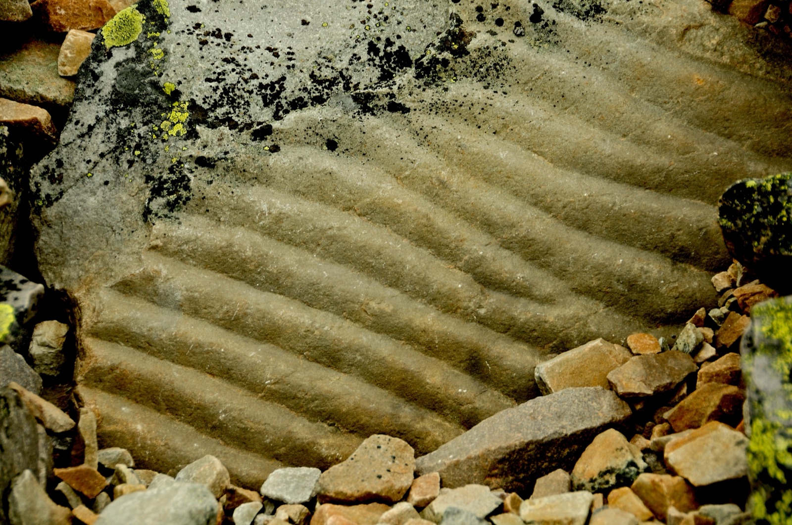
Rundsva (roches moutonnées) — smooth, rounded rock knobs with striations following the direction the ice moved — are signature marks of the last ice age. They are especially clear in Western Norway, where the ice was at the pressure-melting point and could scour the surface beneath it.
Botnbreer (cirque glaciers) have carved out some of Norway’s sharpest peaks. Wind-blown snow settles on the lee side of mountains, forms small glaciers over time, and cuts into the mountainside. After several ice ages the mountain gains steep edges and becomes pointed.
Jettegryter (giant’s kettles) — perfectly circular pits in rock, up to tens of metres deep — form when meltwater along the glacier edge rotates stones that grind themselves down. Many are found dry today, high in the mountains.
Eskers and drumlins are ridge formations created by ice and meltwater — the first when water has filled tunnels beneath the ice, the second when ground moraine has gathered around a rock core.
Ablation moraines are rock and sand that lay on top of or inside the glacier and were simply left where the glacier melted. The explanation for the huge, solitary boulders out in the middle of the plateau.
Rock types — three main categories
In Norwegian geology you meet three large rock-type families. Each formed under its own conditions:
Igneous rocks (solidification rocks)
Formed from solidified magma. Examples:
- Granite — solidified deep down, large crystals
- Gabbro — like granite, but darker (more iron and magnesium)
- Basalt — solidified at the surface, fine-grained
- Pegmatite — granite with extremely large crystals
Sedimentary rocks
Formed when deposits (sand, clay, lime, organic material) are pressed and cemented together. Examples:
- Sandstone — from sand grains
- Limestone — from shells and lime-bearing material
- Mudstone and shale — from clay
- Conglomerate — from rounded stones glued together
Metamorphic rocks (transformation rocks)
Formed from existing rocks that have been subjected to high pressure and heat deep down. Examples:
- Gneiss — from granite or clay, the most common in Norwegian basement rock
- Mica schist — from mudstone, easy to split
- Quartzite — from sandstone
- Marble — from limestone
Minerals
Minerals are the building blocks that rocks are made of. The most common in Norwegian nature:
- Quartz — the most common, transparent to whitish, makes the “clear” pieces of rock
- Feldspar — most of the pink to white rock surfaces, dominant in granite
- Mica — flakes that glitter (muscovite = silver, biotite = dark)
- Calcite — in limestone and marble, reacts with acid
- Pyroxene, olivine — common in dark rocks
- Magnetite — magnetic, can disturb a compass
See all rock and mineral articles →
The Norwegian landscape — where you find what
The geology varies regionally:
- Western Norway — granite and gneiss, dramatically scoured by the ice, deep fjords
- Eastern Norway — sedimentary rocks (the limestone and mudstone of the Oslo Rift), rivers have done the cutting
- Trøndelag — Caledonian schist and gneiss
- Northern Norway — from basement rock to Caledonian schist; jasper, amethyst and other semi-precious-stone areas
- Jæren and Trøndelag — the best farming areas, on fine clay deposited after the ice age
Norwegian references
The geology of friluftsliv has a number of solid Norwegian resources:
- The Geological Survey of Norway (NGU) — maps, reports, popular science
- The Natural History Museum (UiO) — exhibitions and reference books
- Statens kartverk (the Norwegian Mapping Authority) — maps with geological information
- Turlederboka (DNT) — has a good chapter on geology for the trail
For learning in the field: bring a good field guide, a loupe, and a rock hammer (allowed in utmark for hobby purposes, not in protected areas).
Learn more
Each rock and each mineral is its own article — work through the geology category for concrete examples. You do not know the landscape until you recognise the stones that build it.
Text: Snuitide (2022), based on Turlederboka (DNT, 2010), revised 2026.
Key resources: Norges geologiske undersøkelse (NGU) · Naturhistorisk museum (UiO) · Norsk geologisk forening
Sources: Blystad, J.T. (red.) (2010). Turlederboka. Oslo: Den Norske Turistforening. · Nesje, A. & Williams (chapters on Quaternary geology).