Trip Planning
Example trip plans
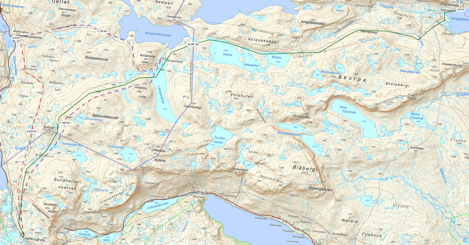
Image 1: Example of route choices on a mountain hike from cabin to cabin. The green line is plan A, the dashed purple line is plan B and the dashed red line is plan C.
Contents
Example of plan A, B and C for a mountain hike
Image 1: Example of route choices on a mountain hike from cabin to cabin. The green line is plan A, the dashed purple line is plan B and the dashed red line is plan C. Map base: Norgeskart.no
The planned route is a long day’s march over rough terrain in Skarveheimen. Plan A (green line) is to walk from Geiterygghytta to Iungsdalshytta. See the map below for more detail. This is a trip of over 25 kilometres as the crow flies, and a day’s march that should be undertaken by experienced hikers carrying light loads. The trip runs through a mountain area 1200–1500 metres above sea level. That high up you are particularly exposed to weather and wind, and you may also encounter snow in summer and autumn.
It is an experienced party of five going on the trip. Turid, Pål, Hanne, Petter and Amund are walking with light packs of around ten kilos. They are going to sleep indoors at Geiterygghytta and Iungsdalshytta, but have brought light sleeping bags in case they have to sleep outside. They have brought a good day’s ration of food, both sandwiches and nuts and chocolate. Otherwise the plan is to buy food at the cabins.
They expect to spend about nine hours on the trip. That includes about an hour’s break in total. The walking time is then three kilometres an hour. The trip is planned for September, and it is still light for a while in the evening — sunset is around 8 p.m. They plan to set off by 9.30 at the latest, with an expected arrival at 6.30 p.m. About halfway along the trip, at Kongshelleren, they will take their first long break. At the same time they will assess the route onwards. The plan is to take another break somewhere in Vestre Iungsdalen.
They have drawn up the following division of responsibilities:
- Food – everyone buys what they want to bring individually.
- A minimum of four sandwiches with toppings.
- One large bar of chocolate or a bag of nuts
- A thermos of a hot drink
- Equipment – everyone has packed on the basis of the trekking association’s equipment list for summer trips.
-
The packs hold 40–60 litres and have a rain cover on the outside
- All equipment is packed in plastic bags to keep it dry
-
Equipment list
| On your body/in your pack
- everyone | Shared equipment | First-aid items - Turid’s responsibility | | --- | --- | --- | | Waterproofs (jacket and trousers) | Knife/leatherman
- Turid and Hanne | sports tape | | Thin windproof jacket and walking trousers | Bothy bag 2 pcs
- Hanne and Pål | 1 pack of Compeed | | Two sets of wool base layers | Duct tape
- Amund | 5 wound-cleaning wipes | | Two pairs of wool socks | Rope - about 15 metres and 5 mm thick
- Petter | A small bottle of eye-rinse | | Down jacket/thick wool jumper | Plastic cable ties for repairing things
- Pål | 1 burn dressing | | Hat | Sleeping mat
- Turid and Petter | 1 pair of scissors | | Felted wool mittens | Reflective bands
- Pål and Amund | 1 support bandage (heavy-duty type) | | Light indoor shoes | | 1 sterile compress | | Mountain boots | | 1 field dressing | | Light sleeping bag | | 5 cable ties | | Toiletries and a small/light towel | | 5 plasters | | Sunglasses | | 2 plasters 5x5 cm | | Map, compass and map case | | 2 bandages 10x10 cm | | A little toilet paper, hand sanitiser and a spare rubbish bag | | 1 elastic gauze bandage | | Matches/lighter | | 1 pack of paracetamol (500mg) | | Head torch with spare batteries | | 1 pack of ibuprofen (400 mg) | | Food for one day and a thermos of a hot drink | | | | Money/card | | | | Power bank for phone | | | | Gaiters | | |
-
Plan B
The dashed purple line follows plan A for about 11 kilometres, up to Kongshelleren tourist cabin. In bad weather, or for other reasons that mean you cannot follow the planned route, it is possible either to stay overnight at Kongshelleren or to carry on westwards to Steinbergdalshytta. The trip via Kongshelleren to Steinbergdalshytta is about 19 kilometres and thus a good deal shorter than to Iungsdalshytta. Plan B can therefore be adjusted in length to 11 or 19 kilometres. Plan B is also a route that is somewhat closer to a road.
The dashed red line is the shortest route, 9 kilometres due north from Geiterygghytta to Steinbergdalshytta. Note that this route should be avoided in a strong northerly wind, since you would then be walking straight into the wind. In that case it would be better to go via Kongshelleren. If the weather is very bad, you should consider staying at the same cabin for another night rather than heading out into foul weather or very poor visibility.
As a safety measure the trip participants are carrying two sleeping mats, two bothy bags and a sleeping bag each in case they have to spend the night outside. They have also brought head torches and reflectors so that they can find their way more easily if it gets dark and so that they are more easily seen should they need help.
Plan C – crisis plan
The map shows no emergency shelters. Kongshelleren tourist cabin is halfway along the route, and they have it as a fallback option. Pål has also brought a lined Jerven Bag, and Hanne has a bothy bag. They reckon they can make an emergency shelter with room for everyone using these two bothy bags. The route choices are the same as the two options for plan B if they have to make changes; they do not want to start walking off the path.
Of the five people, it is Turid who has the most experience with first aid — she has just been on a first-aid course with the Red Cross. She is therefore responsible for the first-aid kit. In advance they have gone through and assessed which first-aid equipment they need. The group knows that the first-aid items are in the lid compartment of Turid’s pack.
There is mostly decent reception until they reach Kongshelleren, then virtually no reception until Iungsdalshytta. Towards Steinbergdalshytta there is reception. They have considered the need for a Spot or a satellite phone, but judged it unnecessary. There is a fair amount of tourist traffic on the trail they are going to walk, and they believe these others will provide extra safety — both to be able to get extra help should something happen, and to be able to raise the alarm. In the event of an accident it can take a great many hours before help can arrive from outside. Especially if a rescue helicopter cannot come, because then ground crews have to make their way in from either Geiterygghytta, Steinbergdalshytta or Iungsdalshytta, as these lie by the road.
Image: Screenshot from Telenor’s website.
Image: Screenshot from Telia’s website.
Given that there are five of them on the trip, they consider it unlikely that they will get separated from one another. They agree all the same that they should never walk so far apart that they lose sight of anyone. Should someone in the group still get separated from the others, they agree first to stand still for 20 minutes to see if the person turns up. Then to walk towards the last place they are sure they saw the person and search the stretch in between. If someone is injured, they make an assessment of whether he or she can continue or not. If the injured person has to turn back, two people should go together. If it is a more serious injury they cannot deal with themselves, they should call for help. With bothy bags, sleeping bags and sleeping mats they reckon they have enough equipment to keep both the injured person and the rest of the party warm. Transporting an injured person would be very difficult, but if they have to carry the injured person they intend to make a stretcher out of the bothy bags and a sleeping mat.
Example of plan A and B for a canoe trip
Image 2: Example of route choices on a canoe trip. The green line is plan A, the red line is plan B. The dashed lines are adjustments to the route in case of paddling in a lot of wind. Map base: Norgeskart.no
Plan A
for the canoe trip is to set off from Hogstad and head in to Fattlia and sleep one night. Most of the participants have little canoeing experience. Plan A is drawn in green, and it is a little over 3 kilometres to paddle. This route mostly runs close to land and sheltered from wind in most wind directions. The last stretch is exposed to a northerly wind. An alternative is therefore drawn in to paddle right along the shore the whole way, shown in grey.
The participants on the canoe trip are a sports class of 25 pupils on their first trip together. They have swimming lessons at school and most are good swimmers. Two of the pupils are, however, uneasy in water, although able to swim. About half the pupils have tried canoeing before, but none of them knows different paddle strokes or buddy rescue. They are to have one overnight stay on the trip, in tents, and therefore have a fair amount of equipment with them in the canoes.
The pupils are divided into tent groups of five people each. The tent groups have planned food and shared out shared equipment within the group. On the trip the teacher has an overview of the five groups, as well as a class list with phone numbers for pupils and parents. There are two teachers on the trip; they are each responsible for a first-aid kit.
The pupils have brought the following equipment and food
| On your body/in your pack
- everyone | Shared equipment
- per tent group | Food
- per tent group | | --- | --- | --- | | Waterproofs (jacket and trousers) | Tent with room for at least 5 pcs. | Breakfast, either bread-based food or hot food | | Thin windproof jacket and walking trousers | Camp stove | Lunch – packed sandwiches for days 1 and 2. No option for hot food | | Two sets of wool base layers | Gas | Dinner – the tent groups plan their own dinners | | Two pairs of wool socks | Spoon | A little extra food for snacks | | Down jacket/thick wool jumper | Spatula | | | Hat | Matches | | | Felted wool mittens or gloves | Rope – for tying the pack into the canoe | | | Waterproof shoes to wear in the canoe | Extra water – 5 litres per group | | | Sleeping bag | | | | Toiletries and a small/light towel | | | | Sunglasses | | | | Map, compass and map case | | | | A little toilet paper, hand sanitiser and a spare rubbish bag | | | | Matches/lighter | | | | Head torch with spare batteries | | | | Swimwear | | | | Insect repellent | | | | Power bank for phone | | | | Sleeping mat | | | | Water bottle | | | | Plate and cutlery | | |
Day 1
10 a.m. Meet-up. Check equipment and carry canoes down to the water. 10.30 a.m. Buddy rescue, canoe. Put on swimwear, or wool base layers if the weather is cold. Everyone is to try capsizing and rescuing a canoe at least once. Those who have finished the rescue change into dry clothes, eat lunch and pack the canoe. One teacher on land, one in a canoe.
12 p.m. Departure, heading for the campsite. We sit two by two in the canoe, and may have an extra canoe in tow if there is a lot of luggage. The luggage is fastened with a loose rope in the canoe so that it does not sink in the event of a capsize.
2–3 p.m. Arrival at camp.
3–4 p.m. Pitch tents.
4–6 p.m. Eat dinner and entertainment.
7 p.m. and onwards, campfire on the beach.
Day 2
9 a.m. Breakfast
10 a.m. Strike camp.
12 p.m. Departure from camp and paddle back.
2–3 p.m. Arrival
3 p.m. Wash and put away canoes. Put away paddles and vests. Joint closing.
Plan B
is an alternative that is a kilometre shorter and offers the option of starting and finishing at different places. The route is drawn in red. The starting point is the same start place as plan A, and in a northerly wind you can paddle with the wind at your back the whole time. This route is more exposed to wind, but here too it is mostly possible to paddle along the shore. The dashed orange line is an alternative for getting more shelter from the north-west, while the red line gives more shelter from the north-east. With a lot of northerly wind on the way home from Breiholmen it is possible to paddle the canoes southwards to Lammaneset or Nautaneset and then take the canoes out there, since there is a road for cars there.
Given that the routes are so short and close to a road, no alternative overnight stay has been planned. But it is possible to come ashore at more or less every spot you paddle past.
As a safety measure everyone paddles wearing a vest, and they carry out buddy rescue in a canoe ahead of the trip. Trip equipment is packed waterproof and fastened with rope to the canoe so that it does not get lost in the event of a capsize. We have also brought spare paddles.
Suggested contents for a crisis plan
Suggested crisis plan. Prepared by Gina Wigestrand, Snuitide
Suggested crisis plan. Prepared by Gina Wigestrand, Snuitide
Next steps
- Trip plan and risk assessment — the framework for plan A/B/C
- Route choice and SARTto — from route to plan
- The fjellvettreglene — the nine rules of thumb
- Trip planning — the hub
Learn more
- DNT — the fjellvettreglene — nine rules of thumb
- Varsom — hazard warnings for avalanches, floods and landslides
- UT.no — routes, cabins, warning data
- Yr.no — weather forecast