Teacher's Guide
Avalanches - calculating safe travel
A suggested competence aim: 'Avalanches - calculating safe travel'
-
Competence aim
A suggested competence aim: “Avalanches - calculating safe travel”
Where there is a risk of avalanche, you can use a map and mathematics to work out the safest route through the terrain.
The three-times rule
If you are 500 metres below the top of a mountain where there is a risk of avalanche, you must be three times as far away, that is 1500 metres from the top, to be completely safe.

Illustration: nyhetsgrafikk.no CC-BY-NC-SA-4.0
Task
A skier is standing at the red arrow on the map and is on a trip along the dashed route that continues round Halletjørne. The ice on the water is safe, and the skier wants to go straight across the water to save time.
It looks as though there may be a risk of avalanche on the mountainside Nattane.
Use the information above about the three-times rule to work out the route the skier should follow in order to avoid being in the danger zone in the event of an avalanche.
On the map, the contour interval is 50 metres.
a) Draw an auxiliary diagram of the mountain with measurements.
b) Calculate the runout angle.
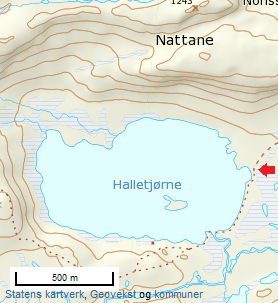
c) How far from the mountain should the skier go? Use the information above.
d) Work out the runout angle if you follow the three-times rule.
e) Will the skier cross the water safely with regard to avalanche?
Suggested solution:
Snøskred - Matematikk 1P-Y - BA - NDLA
Next steps
- Teaching guide — the hub
- Turning back in good time — pupil-facing, on judgement
- Life-saving first aid — practical grounding
- Trip planning — plan safe trips
Learn more
- UDIR — the Friluftsliv programme subject — curricula and competence aims
- NDLA — friluftsliv — digital learning resource
- Norsk Friluftsliv — professional organisation
- DNT — schools — courses and trips for school classes
Text: Elisabet Romedal, NDLA (CC BY-SA)
-
Sources
Nyhetsgrafikk.no (u.å.) Tregangerregelen snøskred nb. [Illustrasjon]. NTB Scanpix. Hentet fra https://ndla.no/subject:1:e1272473-7361-4129-8bfd-a0d6ebc8cf98/topic:10:8a5f5ad6-30ba-4f6d-abc1-606a98c676c4/topic:2:72c1d305-8af6-4c69-8cd1-4a7320a2f829/resource:1:97387
Statens kartverk (u.å), Norgeskart [Kart]. Hentet fra https://ndla.no/subject:1:e1272473-7361-4129-8bfd-a0d6ebc8cf98/topic:10:8a5f5ad6-30ba-4f6d-abc1-606a98c676c4/topic:2:72c1d305-8af6-4c69-8cd1-4a7320a2f829/resource:1:97387
Utdanningsdirektoratet. (2020). Læreplan i aktivitetslære (IDR01‑02). Hentet fra https://www.udir.no/lk20/idr01-02
Utdanningsdirektoratet. (2020). Læreplan i friluftsliv (IDR07‑02). Hentet fra https://www.udir.no/lk20/idr07-02
Utdanningsdirektoratet. (2020). Læreplan i kroppsøving (KRO01‑05). Hentet fra https://www.udir.no/lk20/kro01-05
Utdanningsdirektoratet. (2020). Læreplan i matematikk fellesfag Vg1 teoretisk (matematikk T) (MAT09‑01). Hentet fra https://www.udir.no/lk20/mat09-01
Utdanningsdirektoratet. (2020). Læreplan i matematikk fellesfag Vg1 praktisk (matematikk P) (MAT08‑01). Hentet fra https://www.udir.no/lk20/mat08-01
Utdanningsdirektoratet. (2020). Læreplan i matematikk fellesfag 2P (MAT05‑04). Hentet fra https://www.udir.no/lk20/mat05-04